

In our report, High School Choice in NYC, the Research Alliance found—perhaps not surprisingly—that most students prefer to attend a high school that is relatively close to home. On average, rising 8th graders’ first-choice school was about a half an hour away by public transit. Low-achieving students (i.e., those who scored in the bottom 20 percent of state ELA and math tests) selected schools that were slightly closer than their higher-achieving peers (31 minutes from home, on average, compared to 33).[1]
It makes sense that students would prefer not to travel a long distance to get to school. But this practical reality has implications for a high school choice system designed to provide access to schools throughout the City—especially when we recognize how highly concentrated low-achieving students are in poor neighborhoods:
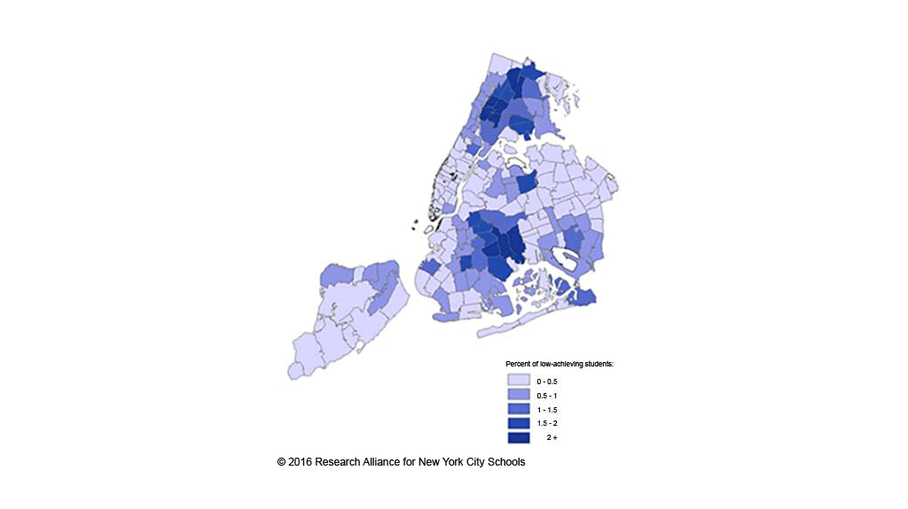
- In 2011, a significant share of low-achieving 7th graders lived in the Central and South Bronx; East and Central Harlem and Washington Heights in Manhattan; parts of Central Brooklyn, including Brownsville, East New York, Cypress Hills, and Flatbush; and north and southeast sections of Queens, such as North Corona, Rochdale, and Far Rockaway.
- Remarkably, nearly one in four low-achieving students resided in one of only ten zip codes in the City (out of 480), including seven in the Bronx and three in Brooklyn.
Geographic Distribution of Low-Achieving Students by Residential Zip Code, 2011[2]
In theory, school choice policies provide an avenue for students to enroll in schools citywide, but in practice, students are constrained by familiarity with a school and willingness to travel. Indeed, our findings show that low-achieving students chose less selective, lower-performing, and more disadvantaged schools than their higher-achieving peers—choices that appear to be driven, at least in part, by geography.
Big Questions
- What is the supply of high-quality school options in and near the neighborhoods where low-achieving students reside?
- In what ways do students consider geography and travel time when making their high school selections? What information sources do they use to explore these questions?
- Fundamentally, how should school choice policies account for the concentration of poverty/disadvantage in particular geographic areas?
What other questions should we be asking? Are you exploring any of these topics? Let us know via email.
This post was developed using data provided to the Research Alliance for New York City Schools by the NYC Department of Education. Analyses conducted by Sean Corcoran, Lori Nathanson, and Christine Baker-Smith.
Footnotes
[1] The NYC DOE also prohibits students from choosing schools more than one hour and 45 minutes from home, one way, although it is unclear how binding this rule is.
[2] Source.
Note: There were 15,177 low-achieving students in our study population in 2011. Low-achieving students are defined as those scoring below the 20th percentile in one subject (ELA or math) and no higher than the 50th percentile in the other subject.
How to Cite this Spotlight
Corcoran, S., Nathanson, L., Baker-Smith, C. 2016. "How Does Concentrated Poverty Intersect with High School Choices?" Spotlight on NYC Schools. Research Alliance for New York City Schools.